


Lorem ipsum dolor sit amet, consectetur adipiscing elit. Donec mattis maximus massa. Morbi in odio varius, tincidunt dolor vel, varius turpis. Morbi hendrerit, quam quis porttitor tempor, erat leo aliquam purus, eget vestibulum ante elit in augue. Aliquam magna mi, feugiat sit amet orci at, finibus cursus sem. Proin non libero arcu. In ante mi, ornare eu justo euismod, consectetur pellentesque justo. In varius, nibh sit amet condimentum vehicula, ligula magna fermentum lectus, laoreet dignissim felis neque ac lectus. Sed eget sollicitudin ligula. Sed sapien ligula, dignissim ut facilisis vitae, ultricies et odio. Nam ultrices quam id ex aliquet, ut ultricies ante placerat. Orci varius natoque penatibus et magnis dis parturient montes, nascetur ridiculus mus. Integer ut erat euismod, accumsan arcu quis, aliquam nulla. Maecenas eget porttitor dolor. Morbi at ex ac augue euismod feugiat. Duis augue augue, egestas vitae lorem sit amet, condimentum imperdiet est. Sed dolor elit, rutrum sit amet magna ac, ultricies gravida ligula.
Nunc vitae nisi eros. Pellentesque non nibh at purus fringilla aliquam. Vivamus eleifend nisl et dui commodo viverra. Nulla lacinia at arcu quis aliquam. Donec ultricies tellus ligula, vitae commodo ipsum ultricies sit amet. Sed sodales, justo a porttitor pellentesque, lorem ipsum facilisis turpis, eu dapibus urna ipsum nec urna. Vestibulum egestas leo sit amet turpis tempor, vel ullamcorper erat finibus. Vivamus non maximus orci, quis finibus elit. Curabitur posuere sem sed nisi varius, at facilisis ipsum cursus. Nam dignissim, dolor vel gravida aliquam, ipsum neque faucibus mauris, non vulputate libero dolor et arcu. Vestibulum dapibus ipsum pellentesque pretium venenatis.
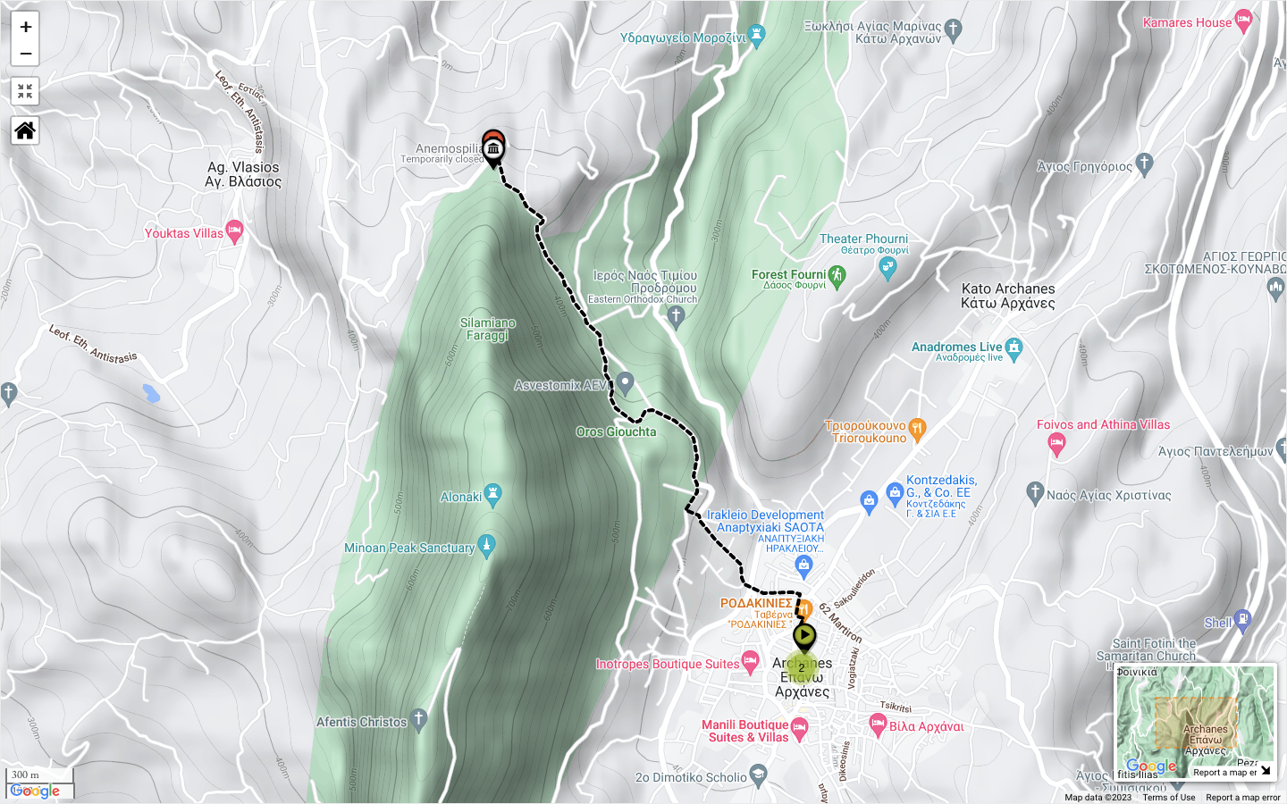
Map & Track
km 01 — 63 (of 250)
Vom minoischen “Palast” im Tourkogeitonia-Viertel von Archanes ging es für etwas mehr als drei Kilometer auf relativ guten Straßen zum Parkplatz vor dem Tempel von Anemospilia auf ca. 420m üNN. Da der Palast selbst schon recht hoch auf ca. 390m üNN liegt, beträgt die Höhendifferenz nur etwa 25 Meter. Doch weil der Weg zwei Mal in Richtung des Flusbetts des Katsambas hinab- und dann wieder hinaufführt, sind Gesamtanstieg und -abstieg im Vergleich dazu relativ umfangreich.

TERRAIN
Mountainous

DISTANCE
7.87 km (4.89 mi)

DURATION
ca. 4 hrs

ALTITUDE DIFF.
ca. 417 m (1,368 ft)

ASCENT
612 m (2,008 ft)

DESCENT
612 m (2,008 ft)

HIGHEST
785 m (2,575 ft)

LOWEST
368 m (1,207 ft)
DIFFICULTY
■ Easy
SURFACE
Gravel Road
SCENERY
●●●●○
CULTURE
●●●○○
Die Lage von Anemospilia
Grandiose Aussichten vom Fuß eines "heiligen Berges"
Anemospilia ist einer von vier Tempeln bzw. Heiligtümern des in der Antike als heilig geltenden Berges Giouchtas (gr. Γιούχτας) und liegt auf einem kleinen Plateau auf dem Rücken der langgezogenen Felsnase des Nordhangs auf ca. 440 Metern Höhe üNN. Der Nordhang des Giouchtas hat keinerlei hohen Baumbewuchs, ist der Witterung ausgesetzt und sehr windig — daher stammt wohl auch der Name Anemospilia (gr. Ανεμόσπηλια = “Windhöhle”). Der Aufstieg zum Heiligtum von der Straße her ist kurz und führt über raues Karstgestein. Leider ist der Grabungskomplex seit einiger Zeit weiträumig umzäunt und für die Öffentlichkeit geschlossen.
Von dem Plateau aus eröffnet sich ein atemberaubender Blick sowohl auf das Dikti-Gebirge im Osten als auch das Ida-Gebirge im Westen, aber vor allem auf die gesamte nördliche Ebene und den dahinter liegenden Golf des heutigen Heraklion. Von dieser prominenten Stelle aus lassen sich bei guter Sicht (und stets mit der Sonne im Rücken) in einem großen Weitwinkel alle Bewegungen zu Land und zu Wasser beobachten – eine Tatsache, auf die wir noch zu sprechen kommen werden. Die minoische Metropole Knossos war von Anemospilia lediglich 5 km entfernt; deren Hafen Poros-Katsambas knapp zehn Kilometer.
Did you like this?
Say hello via social media or drop me an e-mail...
![]()
![]()
![]()
![]()
![]()
![]()
![]()
![]()
![]()
![]()
![]()
![]()
Become Our Trail Angel
Support our work
If you are truly grateful for the impressions and inspiration you receive through travel4stories, we would be delighted if you would become one of our “Trail Angels” and help fill our little digital piggy bank with travel karma. This project is only possible thanks to supporters like you. Even small amounts carry us over long distances.
What goes around, comes around… As a proof, I say thank you for every single donation with a beautiful postcard—mailed directly to your (or a friend´s) physical mailbox. All you have to do is fill in the desired address. Recurring donors get multiple postcards per year. If you don´t need/want postcards, you can still use the donation form and just ignore the address lines.
*Click on the button above and follow three simple steps in the pop-up form of our trusted partner donorbox. Checkout is possible via credit card and PayPal. You can select a one-time or a recurring donation. For recurring donors, a donor account is created automatically. Account setup info will be mailed to you. You have full control over your donation and you can cancel anytime. Your personal data is always secure.
If you prefer donating in other ways, you can become our Patreon, or support us directly via PayPal.
The possibilities to support us with good travel karma are near endless.
Please click here to see them all.
We would like to thank all our supporters from the bottom of our hearts!
Read Great Stuff
Discover Stories & Images, Tours & Trails, Travel Series, and More...
Alpine Crossing Stage 01 — Through the Bregenz Forest
Alpine Crossing, Stage 01: From Oberstaufen (Allgäu, Bavaria, Germany) along the "Cheese Street of the Bregenz Forest" to the Balcony of the Great…
Comments
We´re curious what you think