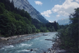
Tibet is much more than just the tightly restricted Tibet Autonomous Region (TAR). The Tibetan Plateau extends far to the east, with the ancient Tibetan region of Kham existing — accessibly — in the far west of the provinces of Sichuan and Qinghai, allowing visitors to the area to experience a Tibetan landscape and culture without the restrictions of travelling to the TAR. Likewise, with its breakneck pace of road construction, it can be difficult to find off-pavement routes in China lasting more than a part of a day.
This route follows a series of dirt roads and tracks skirting along the eastern border of the TAR, taking 4-6 days and starting in the west Sichuan crossroads town of Manigango. It crosses the spectacular 4900m Cho La pass on dirt, descends to a river valley at 3500m, then turns north into the Si Chu Valley along unnamed backcountry track through high grassland dotted with grazing yaks and past tiny villages populated by herders. A spur northwest leads on through unpopulated country on increasingly rough and river-crossed track before climbing to a pass at 4500m, with a fast, rippy descent to a river valley on the other side, and a more gradual descent to County Road X038. This winding dirt road runs west along the hillside high above valley grassland below, passing villages and monasteries, with a wall of snowcapped mountains rising all along its length to the south. It then descends to the market town of Luoxu, following the Chiang Jiang river west on sometimes hairy dirt road cut into the cliffside above the river. Crossing the river on a single-lane suspension bridge, the route climbs north along the west bank of the river before turning west into a broad valley bounded to the north and south by high mountains. This eventually leads on to major highway G214, and about 30 paved kilometres north to the city of Yushu. The centre of Yushu Tibetan Autonomous Prefecture, Yushu has transit connections onward by air and road to the rest of China.
This route is best suited to those with a bit of time in the region who would like to get off the pavement and explore rural Tibet away from the popular routes connecting the big monastery towns. It can, however, also be done by bikepackers on shorter schedules, with reasonable access to the start of the route possible with a few extras days by catching transport onto the Tibetan Plateau from Chengdu. Total vertical ascent for the route is around 5500m. I did this route on a rigid 29+ platform, which was ideal. Much of the route would also be suitable on gravel bikes running high-volume tyres. An extended section of the backcountry track, however, is very rough and would pose a problem for skinnier tyres.

Map & Track

LANDSCAPE TYPE
Mountains

DISTANCE
36.79 km

DURATION
5 hrs

ALTITUDE
402 m

CLIMB
569 hm

DESCENT
269 hm

HIGHEST
903 m

LOWEST
501 m

TECHNIQUE
●●○○○

FITNESS
●●●○○
SCENERY
●●●●○
ADVENTURE
●●○○○
Tour Information
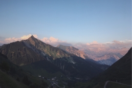
This route was assigned the Mountainbike Intermediate rating, based on the challenge of getting to the start as well as the sheer altitude. The route is not technically difficult for the most part, and the climbs are generally of a very manageable grade. The main difficulty for the route comes from the altitude. If you haven’t been in the region for a while to acclimatise, coping with the route’s elevation (between 3500 and 4900m) can take a toll.
General Highlights
- Incredible mountain scenery across the whole route
- Rolling across the Cho La Pass at almost 4900m
- Rough backcountry riding through the Si Chu Valley
- Fun, fast descents from the high passes
Places to go
- Some gorgeous wild-camping spots
- Heaps of Buddhist temples, shrines, stupas, prayer flags and mani stones
- A genuine look at real Tibetan culture away from the cities
General Advice
- There are a number of excellent Buddhist temples and monasteries near the main route that are worth a detour or side trip. These include famous monasteries in Dege and Ganzi.
- A tunnel is currently under construction that goes beneath the Cho La Pass, and skips 1000+ metres of climbing. Chinese road tunnels are, however, terrifying.
- Language presents a significant difficulty. Google translate is often useless, as few of the people you encounter will be literate in Chinese, which is a second language here, and sometimes may not even be able to speak it.
Tips & Tricks
- When to go: Passes in the mountains will generally be open by May and start getting snowed in by October or so. The route will generally be greener the later in spring you go, and you run less risk of being caught in serious storms (though snow is possible on the passes at any time of year).
- At present, no travel restrictions under an ordinary Chinese tourist visa, though this being China, access to the Kham region (or anywhere in it) can be suddenly closed down at short notice. If applying for a Chinese tourist visa it’s generally best not to mention that you’re heading to a Tibetan area. The city of Chengdu in Sichuan Province is the closest major international airport to the route.
- Reaching the start of the route from Chengdu will require two days of long bus trips from Chengdu to Kangding and Kangding to Ganzi.
- At the end of the route in Yushu, there are flights to Chengdu, Xining, Lhasa and Xi’an.
- Dangers and Annoyances: The possibility of snowstorms in the mountains, heavy trucks on the Cho La pass, and aggressive dogs (I carried a few rocks in my top-tube bag to throw if they got too close).
General Notes
- The route is a wild-camping paradise – just pick a hidden spot off the road and set up a tent.
- The exceptions to this are the ascent and descent of Cho La pass, which features no reasonable places to camp, and the much of the section along the river road between Luoxu and Yushu, which is between a cliff face and a sheer drop.
- Given that this is Tibet, you may also ride up a hidden valley to camp only to find a family of herders living at the far end. In practice, this is seldom a problem, but if you’re setting up camp in someone’s pasture it’s polite to ask if it’s okay when you see them (generally when they’re rounding up animals just before sunset).
Food & Water
- Being the high mountains, fresh water is available at countless places along the route, so you shouldn’t need to carry more than a couple litres at a time. In some cases the streams and rivulets are pure snowmelt with no upstream habitation or grazing, but even in the worst case, much of the route follows rivers that can be safely drunk from with proper treatment (though I generally drank treated water from side streams).
- The towns of Manigango and Luoxu are the major supply points for food, having reasonably well-stocked stores. Smaller villages along the way often have a shop (look for advertising posters pasted to the side of a building) where you can buy basics like instant noodles and biscuits.
Lorem ipsum
Tibet is much more than just the tightly restricted Tibet Autonomous Region (TAR). The Tibetan Plateau extends far to the east, with the ancient Tibetan region of Kham existing — accessibly — in the far west of the provinces of Sichuan and Qinghai, allowing visitors to the area to experience a Tibetan landscape and culture without the restrictions of travelling to the TAR. Likewise, with its breakneck pace of road construction, it can be difficult to find off-pavement routes in China lasting more than a part of a day.
This route is best suited to those with a bit of time in the region who would like to get off the pavement and explore rural Tibet away from the popular routes connecting the big monastery towns. It can, however, also be done by bikepackers on shorter schedules, with reasonable access to the start of the route possible with a few extras days by catching transport onto the Tibetan Plateau from Chengdu. Total vertical ascent for the route is around 5500m. I did this route on a rigid 29+ platform, which was ideal. Much of the route would also be suitable on gravel bikes running high-volume tyres. An extended section of the backcountry track, however, is very rough and would pose a problem for skinnier tyres.
Historical Excursus
Lorem ipsum dolor sit amet, consetetur sadipscing elitr, sed diam nonumy eirmod tempor invidunt ut labore et dolore magna aliquyam erat, sed diam voluptua. At vero eos et accusam et justo duo dolores et ea rebum. Stet clita kasd gubergren, no sea takimata sanctus est Lorem ipsum dolor sit amet. Lorem ipsum dolor sit amet, consetetur sadipscing elitr, sed diam nonumy eirmod tempor invidunt ut labore et dolore magna aliquyam erat, sed diam voluptua. At vero eos et accusam et justo duo dolores et ea rebum. Stet clita kasd gubergren, no sea takimata sanctus est Lorem ipsum dolor sit amet.
Gallery
Did you like this?
Say hello via social media or drop me an e-mail...
![]()
![]()
![]()
![]()
![]()
![]()
![]()
![]()
![]()
![]()
![]()
![]()
Become Our Trail Angel
Support our work
If you are truly grateful for the impressions and inspiration you receive through travel4stories, we would be delighted if you would become one of our “Trail Angels” and help fill our little digital piggy bank with travel karma. This project is only possible thanks to supporters like you. Even small amounts carry us over long distances.
What goes around, comes around… As a proof, I say thank you for every single donation with a beautiful postcard—mailed directly to your (or a friend´s) physical mailbox. All you have to do is fill in the desired address. Recurring donors get multiple postcards per year. If you don´t need/want postcards, you can still use the donation form and just ignore the address lines.
*Click on the button above and follow three simple steps in the pop-up form of our trusted partner donorbox. Checkout is possible via credit card and PayPal. You can select a one-time or a recurring donation. For recurring donors, a donor account is created automatically. Account setup info will be mailed to you. You have full control over your donation and you can cancel anytime. Your personal data is always secure.
If you prefer donating in other ways, you can become our Patreon, or support us directly via PayPal.
The possibilities to support us with good travel karma are near endless.
Please click here to see them all.
We would like to thank all our supporters from the bottom of our hearts!
Read Great Stuff
Discover Stories & Images, Tours & Trails, Travel Series, and More...
Alpine Crossing Stage 01 — Through the Bregenz Forest
Alpine Crossing, Stage 01: From Oberstaufen (Allgäu, Bavaria, Germany) along the "Cheese Street of the Bregenz Forest" to the Balcony of the Great…
Alpine Crossing Stage 02 — Through the Great Walser Valley
Alpine Crossing from Oberstaufen (Allgäu, Bavaria, Germany) to Chiavenna (Lombardia, Italy) via Bregenz Forest, Great Walser Valley, Liechtenstein,…
Comments
We´re curious what you think